


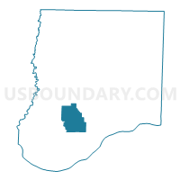
Dixie Voting District, Callaway County, Missouri
About
Outline

Summary
| Unique Area Identifier | 607313 |
| Name | Dixie Voting District |
| County | Callaway County |
| State | Missouri |
| Area (square miles) | 23.45 |
| Land Area (square miles) | 23.31 |
| Water Area (square miles) | 0.15 |
| % of Land Area | 99.37 |
| % of Water Area | 0.63 |
| Latitude of the Internal Point | 38.71816870 |
| Longtitude of the Internal Point | -91.99070600 |
Maps


Graphs
Select a template below for downloading or customizing gragh for Dixie Voting District, Callaway County, Missouri


Neighbors
Neighoring Voting District (by Name) Neighboring Voting District on the Map
- East Fulton Voting District, Callaway County, MO
- Guthrie Voting District, Callaway County, MO
- Hams Prairie Voting District, Callaway County, MO
- Mokane Voting District, Callaway County, MO
- New Bloomfield Voting District, Callaway County, MO
- Tebbetts Voting District, Callaway County, MO
Top 10 Neighboring County Subdivision (by Population) Neighboring County Subdivision on the Map
- East Fulton township, Callaway County, MO (10,231)
- Cedar township, Callaway County, MO (2,937)
- St. Aubert township, Callaway County, MO (1,969)
- Cote Sans Dessein township, Callaway County, MO (1,122)
- Guthrie township, Callaway County, MO (604)
- Caldwell township, Callaway County, MO (438)
Top 10 Neighboring Unified School District (by Population) Neighboring Unified School District on the Map
- Fulton School District, MO (19,130)
- South Callaway R-II Schools, MO (4,457)
- New Bloomfield R-III School District, MO (4,232)